
Watch Duty (Wildfire)
Screenshots


Description
About Watch Duty (Wildfire) Feature – Real-Time Wildfire Intelligence for Public Safety
Watch Duty (Wildfire) is a dedicated mobile application designed to provide the public with real-time, actionable intelligence on wildfire activity. It aggregates and disseminates critical information from official sources, including fire agencies, emergency scanners, and satellite data, into a single, user-friendly platform. The app serves as a vital tool for residents, travelers, and professionals in wildfire-prone regions, offering timely alerts, detailed fire maps, and incident reports to enhance situational awareness and support informed decision-making during fire seasons.
Chapter 1: Function
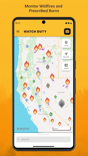
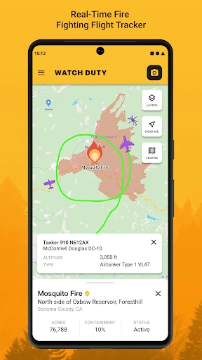
Watch Duty (Wildfire) operates by continuously monitoring and synthesizing data from over a thousand official sources. Its core function is to deliver real-time alerts on new fire incidents, containing key details such as location, size, containment status, and evacuation orders. Users can view active wildfires on an interactive map layered with perimeter data, satellite heat detections, and agency updates. The app provides access to live audio from emergency responder radio scanners, allowing users to hear direct communications from firefighting teams. Additionally, it features a timeline of incident updates, curated by a team of analysts, to offer clear, chronological narratives of fire development. These functions are centralized in a streamlined interface, enabling quick access to life-saving information without unnecessary complexity.
Chapter 2: Value
The primary value of Watch Duty lies in its ability to democratize access to critical, real-time wildfire intelligence, filling a crucial gap between official emergency communications and public need. Unlike generalized weather or news apps, it offers hyper-specialized, consolidated data directly from firefighting command centers, reducing information lag and confusion during fast-moving incidents. Its key advantages include reliability, as it sources from authoritative agencies; comprehensiveness, by combining mapping, scanning, and analyst summaries; and clarity, presenting complex data in an accessible format. For communities, this translates to enhanced personal safety, better preparedness for evacuations, and reduced anxiety through transparent information flow. The app also holds significant value for journalists, researchers, and insurance professionals who require accurate, up-to-the-minute fire data. By leveraging crowdsourced verification and a dedicated analyst team, Watch Duty ensures information is both rapid and vetted, striking a critical balance between speed and accuracy. This focused approach makes it an indispensable utility, empowering users to proactively protect their families, homes, and communities with information that was previously fragmented and difficult for the public to obtain in a unified manner.
Chapter 3: Scenarios
Watch Duty is primarily targeted at residents living in or near wildland-urban interface areas across fire-prone states like California, Oregon, Washington, and Arizona. These users rely on the app daily during fire season to monitor threats near their homes, receive evacuation warnings, and plan safe routes. Travelers and outdoor enthusiasts, including hikers and campers, use it to check fire conditions and road closures before and during trips to ensure recreational safety. Furthermore, the app serves professional user groups such as freelance journalists reporting on wildfire events, property managers overseeing assets in risky zones, and local business owners making operational decisions based on air quality and access. In everyday use, a homeowner might check the app each morning for new incidents within a 50-mile radius. During an active fire, families can follow its progression on the map while listening to scanner traffic to understand firefighter strategies and imminent threats, enabling calm, informed action rather than reliance on rumors or delayed official statements.
Uninstall Instructions
For step-by-step guidance on how to safely remove this application from your device, please refer to our 《Uninstall Instructions》 document.
Pros
- real-time wildfire maps with aircraft tracking
- push alerts for fire perimeters and evacuations
- crowdsourced on-ground reports from volunteers
- minimalist interface focused on critical fire data
- no subscription fees for core life-safety information
Cons
- service limited to specific western US regions
- requires user location for hyper-local alerts
- data density lower outside active fire seasons
- no built-in offline map download functionality
- visual style prioritizes utility over aesthetics
Frequently Asked Questions
What is Watch Duty (Wildfire) and what does it do?
Watch Duty (Wildfire) is a community-powered, real-time wildfire information and alert app. It aggregates and maps data from official sources like CAL FIRE, US Forest Service, and NOAA, providing users with locations, perimeters, and activity updates on active wildfires. Its core function is to deliver timely, location-based alerts and detailed incident information to help the public stay informed and make safety decisions.
Is Watch Duty free to use, and are there in-app purchases?
Yes, the Watch Duty app is free to download and use for accessing core wildfire information and alerts. It is primarily supported by voluntary donations from its user community. There are no mandatory subscription fees or in-app purchases required to access its essential real-time tracking and notification features.
What devices and regions does Watch Duty (Wildfire) support?
Watch Duty is primarily focused on the United States, with its most detailed coverage for states like California. It is available as a mobile app for both iOS and Android devices. The service relies on publicly available official data, so its comprehensiveness can vary by region and the reporting activity of local fire agencies.
How accurate and timely are the wildfire alerts from Watch Duty?
Watch Duty provides near real-time information by aggregating and cross-referencing data from official government and agency sources. While it strives for timeliness and accuracy, all data is dependent on the release schedules and accuracy of its primary sources. Users are advised to treat it as a critical situational awareness tool and always follow official evacuation orders from local authorities.
Does the app require specific permissions or work without cellular service?
The app requires location permissions to provide relevant, proximity-based alerts. For optimal functionality, including map loading and real-time data updates, a stable internet connection (cellular or Wi-Fi) is necessary. Some basic cached data may be viewable offline, but live tracking and new alerts will not be available without a connection.
App Info
Technical Info
Recommended For You

Nail Art Design : Nails Polish
Beauty

AutoExpreso Móvil
Auto & Vehicles

Phoner 2nd Phone Number + Text
Communication

InstaFeet
Beauty

Smartsheet: Projects & Teams
Business

AirTalk Wireless
Business

Yolla: International Calling
Communication

Joyread
Books & Reference

Handy Art Reference Tool
Comics

King James Bible - KJV Offline
Books & Reference

WOMBO Dream - AI Art Generator
Art & Design

Discount Tire
Auto & Vehicles

3D Modeling App: Sculpt & Draw
Art & Design

Kiwi Browser - Fast & Quiet
Communication

AGE-R medicube Digital clinic
Beauty
[KNA008] COMBINE
Art & Design

Daily Bible - KJV Holy Bible
Books & Reference

KakaoTalk : Messenger
Communication

Workforce Tools
Business

Mirror - Fullscreen Mirror App
Beauty